Sunday, 19 December 2021
Geocoding Delivery Addresses
In one of the projects I'm working on (5Dakot), I was building the deliveries system, which was initially structured something like this:
Order: attributes: # ... address_id relations: addressAddress: attributes: user_id, address, address_2, floor, # ... apt, town_id relations: user, townTown: attributes: name, slots, # array of delivery time slots areas # array of areas in this townThe admin could add the Towns they want to offer delivery to, and users could save multiple addresses.
When saving an address, the user would have to select a Town & area from a dropdown that was dynamically populated from the available towns & areas.
Shortcomings
This worked quite well. But the user could still enter an address outside the supported towns, and we just had to rely on the user to understand that we don't deliver outside the listed towns.
Additional Requirements
Sales were booming 🚀🚀🚀.
Grouping deliveries by Town was not sufficient anymore. They wanted to be able to split a Town into Delivery Areas, then be able to set separate delivery slots for each area.
I knew I had 2 options how to build this:
- Getting a list of all streets in Israel, maually assigning each to an area, then in the
Addressform require the user to select from this list of streets. But this would be very tedious... and what do we do if we want to split a long street into multiple areas? - Let the admin literally draw areas on a map, and then automatically attach
Addresses to their corresponding area based on their location. This would be way better!
But this seemed way too complicated... Where do I even start?
Luckily this turned out to be easier than it seemed!
Outline
Let's break it down into smaller pieces:
- Build a UI where an admin can draw an
Areaon a map. - Save GPS coordinates with each
Address. - Automatically attach each
Addressto itsAreabased on its GPS coordinates.
Now let's see what we'll need from the technical side, by updating the above outline:
Order: attributes: address_id relations: addressAddress: attributes: user_id, address, address_2, floor, apt, lng, # longitude lat, # latitude area_id # instead of town_id relations: user, area # instead of town# New!Area: attributes: name, polygon, # this will define the borders of the area slots, # array of delivery time slots town_id relations: townTown: attributes: nameNow that we've outlined it, let's build it!
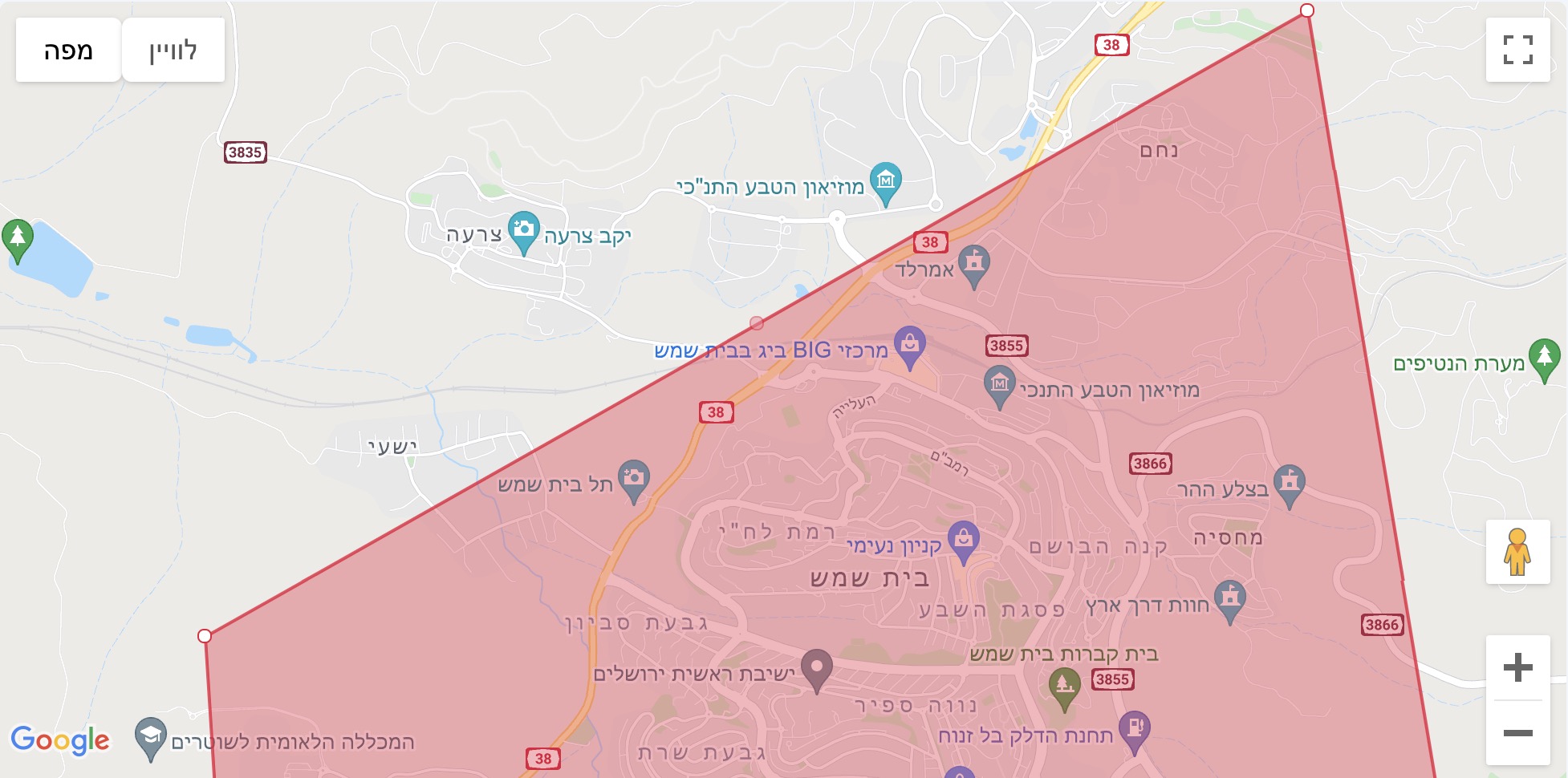
Drawing the Area on the Map
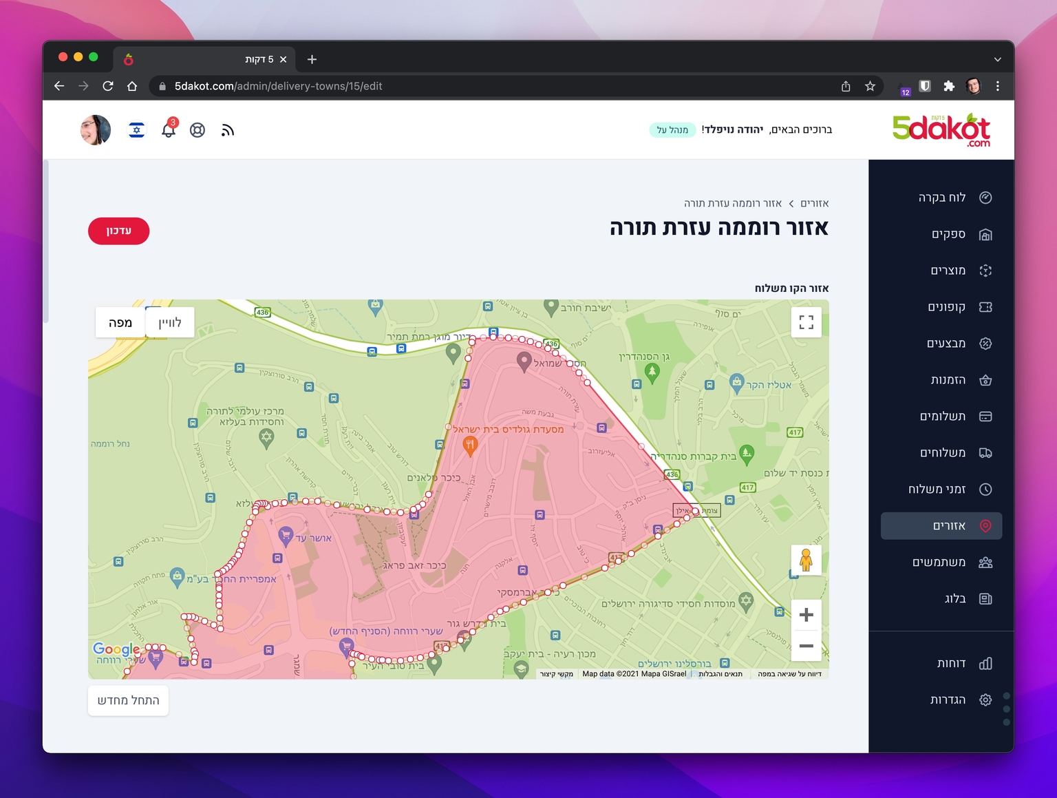
I used the Google Maps API to create the above UI.
The API provides the full functionality for drawing shapes on the map!
What we need, is a Polygon:
A
Polygonrepresents an area enclosed by a closed path (or loop), which is defined by a series of coordinates.Polygonobjects are similar toPolylineobjects in that they consist of a series of coordinates in an ordered sequence.Polygonsare drawn with a stroke and a fill.
With that knowledge in mind, we can create the above UI:
// Initialize the mapmap = new google.maps.Map(document.getElementById('map'), { center: townCoords[0], zoom: 12,})// Construct the polygon.polygon = new google.maps.Polygon({ paths: [ // default starting Polygon { lat: 31.755976167072834, lng: 35.14138275146484 }, { lat: 31.720342984569367, lng: 35.25284960937502 }, { lat: 31.819437779330364, lng: 35.231975524902325 }, ], strokeColor: '#E3163B', strokeOpacity: 0.8, strokeWeight: 2, fillColor: '#E3163B', fillOpacity: 0.35, editable: true, // this is all we need to make the polygon editable on the map! // draggable: true,})polygon.setMap(map) // add the polygon to the mapThis gives us a starting polygon, which is editable on the map by adding/dragging points:
Saving the Area to our Database
All we need to save to our database - is the Polygon, which is just an array of [lng, lat] points. We can save this in a json field on the Area.
When the user clicks "save" we get the Polygon from the map like so:
getPolygon() { let vertices = polygon.getPath() // polygon is defined in the previous snippet let polygonCoords = [] for (let i = 0; i < vertices.getLength(); i++) { const xy = vertices.getAt(i) polygonCoords.push({ lat: xy.lat(), lng: xy.lng() }) } return polygonCoords}Now that the areas are done, we need to add GPS coordinated to the Addresses!
Adding GPS Coordinates to Addresses
I updated the Address form to use Google's Places Autocomplete API, and also made that a user can only select his address from the Autocomplete list, which then also gives us the addresses coordinates.
// Jerusalem center coordinatesconst jerusalem = { lat: 31.7820715, lng: 35.2106184 }// Create a bounding box with sides ~30km away from jerusalem centerconst jerusalemAreaBounds = { north: jerusalem.lat + 0.3, south: jerusalem.lat - 0.3, east: jerusalem.lng + 0.3, west: jerusalem.lng - 0.3,}const options = { bounds: jerusalemAreaBounds, // only give results within these bounds componentRestrictions: { country: 'il' }, // only give results from this country fields: ['address_components', 'geometry', 'name'], // 'geometry' - GPS coordinates origin: jerusalem, strictBounds: true, types: ['address'],}const autocomplete = new google.maps.places.Autocomplete('input-selector', options)// handle user select address resultthis.googlePlacesAutocomplete.addListener('place_changed', () => { const place = autocomplete.getPlace() if (place.geometry.location) { this.address.lat = place.geometry.location.lat() // set address lat this.address.lng = place.geometry.location.lng() // set address lng }})Now we can save the lat and lng coordinates with the Address.
Attaching the Address to an Area
We now have a list of Areas, and an Address with lat & lng. How do we find out in which Area it is located?
Let's break it down.
First we need a way to check if a given Areas polygon contains a given GPS point. Thankfully, there are already open-source implementations of the algrithm needed to do this. I used the mjaschen/phpgeo PHP package:
class Area extends Model { /** * Check if Area contains these coordinates */ public function containsCoordinates($lng, $lat): bool { if (!$this->polygon) return false; $addressCoordinate = new Coordinate($lat, $lng); $polygon = new Polygon(); foreach ($this->polygon as $point) { $polygon->addPoint(new Coordinate($point['lat'], $point['lng'])); } return $polygon->contains($addressCoordinate); }}So now we can check if a given Area contains a coordinate:
$area->containsCoordinates($address->lng, $address->lat); // booleanNow for the nice Laravel finishing touch 😋: We can use Laravel's form validation to ensure that the chosen address is in one of our supported Areas!
class UpdateAddressRequest extends FormRequest{ public function prepareForValidation() { // automatically set `area_id` by finding the Area that contains this address $this->merge([ 'area_id' => Area::findByCoordinates($this->lng, $this->lat)?->id, ]); } public function rules() { return [ 'user_id' => 'nullable', 'address' => 'required', 'address2' => 'nullable|string', 'floor' => 'required|string', 'apt' => 'required|string', 'lng' => 'required', 'lat' => 'required', 'area_id' => 'required|exists:areas,id', ]; } public function messages() { return [ 'area_id.required' => "Sorry, we don't deliver to this area yet.", ]; }}Note how we automatically set the area_id by finding the Area that contains this Address. If we don't find an Area that contains this address, we return a descriptive validation error message to the user - 'Sorry, we don't deliver to this area yet.' 👌
We can now have multiple Areas in a Town, Addresses automatically get attached to their Area, and we can have delivery slots per area.
Extras
I also created an Artisan Command to add coordinates to all existing Addresses (~1700 addresses!) by using the Google Places Geocoding API:
// get lng lat for addresspublic function geocode(){ $result = Http::timeout(3)->get("https://maps.googleapis.com/maps/api/place/findplacefromtext/json", [ 'fields' => 'geometry', 'input' => $this->address, 'inputtype' => 'textquery', 'key' => config('services.google.api_key'), ]); return Arr::get($result->json(), 'candidates.0.geometry.location');}Another thing I need to handle is when the admin updates an Area bounds polygon, all addresses area_id need to be updated.
Conclusion
I really enjoyed solving this challenge, which worked out way better than I thought it would. It was also surprisingly much easier than I thought such a feature would be to implement, thanks to Google Maps APIs, and some open-source libraries.